Maleen Kidiwela

and 3 more

Back-arc basins provide insights into the processes governing the evolution of continental rifting to seafloor spreading. The Bransfield basin hosts a back arc rift that is hypothesized to be in the late stages of this transition. Orca volcano is a submarine volcano that lies on the most evolved portion of the rift. It coincides with a transition in rifting style from a clearly delineated magmatic rift to the southwest to a wide and deeper faulted graben with thicker sediment to the northeast. We conducted an active source tomography experiment to image the three-dimensional isotropic and anisotropic P-wave velocity structure of the upper-crust of Orca Volcano. We developed a method to incorporate secondary arrivals to improve the imaging of the volcano’s magma chamber. The magma chamber extends from ~1 km beneath the seafloor to 3-4 km depth with a maximum melt fraction of 16-41% and melt volume of 0.8-2.3 km3. The southwest rift of Orca volcano is characterized by a narrow zone of low velocities that connects to the magma chamber and by strong rift parallel anisotropy at shallow depths. Its structure is similar to a slow spreading ridge consistent with a rift that is transitioning to seafloor spreading. Extension to the northeast of Orca is more distributed and not clearly linked to the volcano. We infer that the change in extensional style results from a more hydrated and weaker mantle to the northeast that is caused by a tear in the Phoenix slab and a consequent change in slab depth.

Helena Seivane

and 4 more

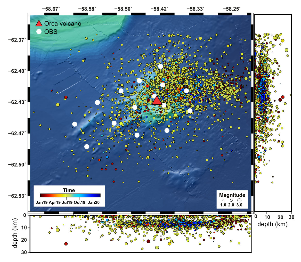
Orca seamount is located in the Bransfield Strait, between the South Shetland Islands and the Antarctic Peninsula. The volcano developed on an extensional rift produced by a combination of slab rollback at the South Shetland trench and transtensional motions between the Scotia and Antarctic plates. From January 2019 to February 2020, the BRAVOSEIS project deployed a dense amphibious seismic network in the Bransfield region, comprising both land and ocean bottom seismometers (OBS), as well as moored hydrophones. We perform an analysis of the seismicity recorded in the area of Orca volcano using a subnetwork composed of 15 OBS around Orca seamount and its SW rift, covering a region of about 20 km x 10 km, with inter-station distances of ~4 km. OBS data are organized, visualized and analyzed using the SEISAN software package. Earthquake detection was achieved through an STA/LTA algorithm. We use a visual procedure including spectral analysis and filtering to discriminate local earthquakes from other types of signals. For earthquake location, we use P and S phase arrivals and a layered model derived from previous geophysical studies in the region. In this way, we identify and locate around 3000 earthquakes with magnitudes in the range from -1 to 3. There is a continuous background level of microearthquake activity, although a large part of the earthquakes occurred during a swarm in June-July 2019. Source depths are mostly concentrated in the first 10 km (within the crust). The epicentral distribution covers the whole area around the volcano, but it is clearly densest in the NE flank, where an intense seismic series started in September 2020.

Karen Bemis

and 2 more

Analysis of the time-dependent behavior of the buoyant plume rising above Grotto Vent (Main Endeavour Field, Juan de Fuca Ridge) as imaged by the Cabled Observatory Vent Imaging Sonar (COVIS) between September 2010 and October of 2015 captures long-term time-dependent changes in the direction of background bottom currents independent of broader oceanographic processes, indicating a systematic evolution in vent output along the Endeavour Segment of the Juan de Fuca Ridge. The behavior of buoyant plumes is a convolved expression of hydrothermal flux from the seafloor and ocean bottom currents in the vicinity of the hydrothermal vent. Plume behavior can be quantified by describing the volume, velocity and orientation of the effluent relative to the seafloor. Using three-dimensional acoustic images by the COVIS system, we looked at the azimuth and inclination of the Grotto plume in 3 hour intervals and identified a bimodal shift in their bending from NW and SW to SE in 2010, 2011, and 2012 to single mode NW in 2013 and 2014. Modeling of the distribution of azimuths for each year with a bimodal Guassian indicates that the prominence of southward bottom currents decreased systematically between 2010 and 2014. Spectral analysis of the azimuthal data showed a strong semi-diurnal peak, a weak or missing diurnal peak, and some energy in the sub-inertial and weather bands. This suggests the dominant current generating processes are either not periodic (such as the entrainment fields generated by the hydrothermal plumes themselves) or are related to tidal processes. The surface wind patterns in buoy data at 2 sites in the Northeast Pacific and the incidence of sea-surface height changes related to mesoscale eddies show little systematic change over this time period. Given the limited bottom current data for the Main Endeavour Field and other parts of the Endeavour segment, we hypothesize that changes in venting either within the Main Endeavour Field or along the Endeavour Segment have resulted in the changes in background currents. Previous numerical simulations (Thomsen et al 2009) showed that background bottom currents were more likely to be controlled by the local (segment-scale) venting than by outside ocean circulation or atmospheric patterns.